MULTNOMAH COUNTY DRAINAGE DISTRICT NO. 1
517 CORBETT BUILDING
PORTLAND OREGON
January 12, 1918.
Col. Geo. A. Zinn,
Corps of Engineers, U.S. Army,
Portland, Oregon.
Colonel:-
We desire to take up with you the matter of closing the slough tributary to the Columbia River in Multnomah County, Oregon, known as Columbia Slough, at or slightly above the point of crossing of said slough by the Union Avenue approach to the Interstate Highway bridge.
This proposed work is necessary to carry out the plans of Multnomah County Drainage District No. 1, a district duly organized under the laws of the State of Oregon for the purpose of reclaiming for agricultural purposes the overflowed lands lying on both sides of Columbia Slough and extending from the banks of the Columbia River to the high lands on the south, about 6700 svtrd. On the east and west ends of the district connections will be made with other organized drainage districts. A map is submitted herewith which shows the location and extent of Multnomah County Drainage District No. 1 and its relation to other districts, highways and waterways referred to herein.
PRESENT CONDITON OF THE DISTRICT:- The overflow lands comprising the district vary in elevation, the immediate banks of Columbia Slough being from 15 to 20 feet above low water and the land farther to the north and south falling to as low as five feet. From the lowest ground the land rises to the northward to the bank of the Columbia River where elevations vary from about 25 feet to over 30 feet on a strip of ground of varying width, but at all points wide enough to support a levee of the dimensions required. On the south the land rises more rapidly. All of the railway and the east and west highways shown being above the highest know water. Scattered over the tract are numerous ponds, most of them connected with the network of sloughs of which Columbia Slough is the outlet, and others not so connected but adaptable to drainage by connecting ditches. The soil is composed of silt of great fertility but on account of annual floods is used only as pasture at times when the stage of water permits, except above elevation 20 where attempts at farming are made with frequent losses of crop by freshets running a little higher than the average.
PROPOSED PLAN FOR RECLAMATION:- It is proposed by the district to take advantage of the high land along the Columbia River for the location of the required level from western boundary of the Sandy Drainage District to the eastern boundary of Peninsula Drainage District No. 2. As the County authorities, after taking the matter up with Messrs. Waddell and Harrington, consulting engineers for the Interstate Highway bridge and approaches, have granted permission to connect levees to their embankment, there remains to completely inclose and protect the lands of our district only the work of closing the Columbia Slough at or near the crossing of the crossing of the highway, where sluice gates, controlling works and pumping plant would be located. The drainage from outside the district is not large and at periods of low water would, together with the runoff from rainfall upon the district, drain through the Columbia Slough and connecting sloughs and ditches to the dam, passing out through the sluiceways provided. Whenever the water level of the river rises to over (about) five feet, pumping will be resorted to, the sloughs, ponds and ditches below that level being utilized as collecting basins during excessive rains that might, for short periods, exceed the capacity of the pumps.
It is estimated that, following the plan above outlined, the work can be completed in time to afford full protection to a crop during the 1919 season at a cost of approximately $35.00 per acre.
Unless Columbia Slough can be so closed the only alternative would be levees on both banks of the slough, dividing the district into two units. These levees being on ground averaging ten feet lower, will require about four times as much material as an equal length of the levee upon the higher ground along the Columbia, and, unless the opening now existing through which water from the Columbia River enters the upper end of Columbia Slough at a stage of ten feet and over be closed, would require to be heavily riprapped, as the closing of all other depressions along the bank of the Columbia would greatly increase the currents through the only opening left, the Columbia Slough.
The extra work would so increase the cost of the reclamation of the district that the project would necessarily be abandoned if it were found impossible to proceed along the lines at first above outlined.
COLUMBIA SLOUGH DATA:- There is, at the present time, no commercial use being made of this slough as a waterway above the point where the district proposes to construct a dam. There has been no such use for years past and there exists, we believe, no probability of such use for an indefinite number of years to come.
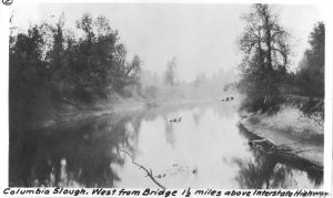
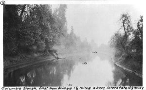
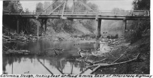
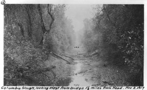
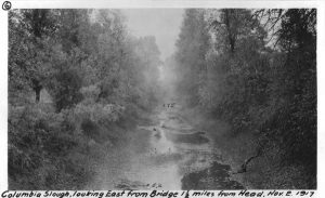
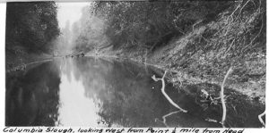
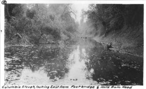
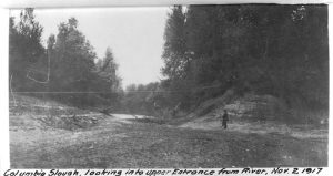
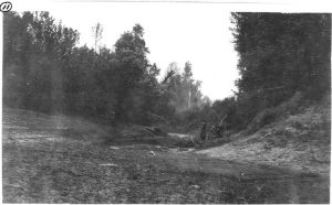
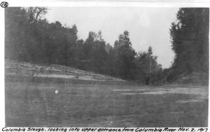
The present physical condition of the slugh is shown by a series of photographs submitted. These were taken on November 2nd, 1917, when the Columbia River was at two foot stage. As a large part of the bed of the slough is above low water level, bottom elevations (in red) are not shown by soundings but are referred to U.S.G.S. datum (0.75 below zero of U.S. River gage at Portland.)
 Photograph No.1 shows the slough at lower limits of the drainage district where it is desired to close it and where the sluice way and pumping plant would be located. The stain on bridge piers shows height of 1917 freshet (23.8 stage at Portland).
Nos. 2 and 3 are views west and east of the point so marked on the map. Beneath the trestle from which these views were taken is an old jam of drift wood completely closing the channel to boats of any size.
No. 4 shows slough at point 4 on map. Water was then about a foot deep.
Nos. 5 and 6 are from point so marked. The stream was here a mere thread which could be stepped across almost anywhere.
Nos. 7 and 8 are from point so marked. Water was from one to two feet deep.
Nos. 9, 10, 11 and 12, are at upper end of slough, showing connection with the Columbia River.
EFFECT OF RECLAMATION DISTRICT IMPROVEMENT ON THE COLUMBIA RIVER:- The probable effect of the prevention of the floodwaters of the Columbia River from overflowing its banks and a portion of the water flowing through Columbia Slough has been carefully considered and it is believed it will be entirely beneficial. During the freshet of 1917, when the river reached a height of 23.8 the Interstate Highway approach closed the entire flood channel south of Oregon Slough excepting the opening shown beneath the highway bridge on photograph No.1. At this point the current was not as great as at the bridge over the main channel of the Columbia, where additional riprap protection was required at the north abutment. a comparison of the area of the opening beneath the Columbia Slough bridge with the combined areas of the flood water channels of the Columbia River and Oregon Slough leads to the conclusion that there would be no appreciable effect on main channel levels and velocitites, and that a greater flood height, even up to the record attained in 1894, would be increased by only a few inches by reason of shutting of the waterway now existing at Columbia Slough. This possible slight increase in flood height in main channel would doubtless result in an increased bottom scour which would have the effect of offsetting the loss of flood channel area.
EFFECT ON COLUMBIA SLOUH AT HIGH WATER:- The Columbia River water at flood stages is of a high ratio of turbidity and
Any opening of the connection of the head of Columbia Slough with the Columbia River would therefore, unless such opening were of a size sufficient to give a practically uniform current velocity throughout the slough, result in heavy deposits, requiring frequent dredging, in the lower reaches of the waterway; conversely, a complete closing of the slough at flood stages will prevent any deposit and obviate the necessity for dredging for maintenance of channel in the slough below the dam.
EFFECT ON COLUMBIA SLOUGH AT LOW WATER:- As all seepage, rainfall, and runoff from the adjacent high lands will be pumped over the dam or flow by gravity through the sluiceways, there can be no difference whatever in the low water current of the slough below a ten foot stage after completion of the proposed reclamation work. Above that stage there is at present some flow through the slough from the Columbia River but until a stage of 14.5 is reached, not sufficient to cause any appreciable current, the flushing of the slough at the present time at low water stages, except during heavy rainfalls, being effected almost entirely by the tides.
OBJECT OF PROPOSED IMPROVEMENT:- The sole object of the proposed district improvement is to make productive by creating conditions favorable to its full use for agricultural purposes, the land within the district. This project, by reason of the great fertility of the soil, its accessibility and the pracitcability of its reclamation if the work be permitted to proceed along the lines herein set forth, makes a strong appeal for support by the adjacent city of Portland, the agricultrual, dairying and livestock interests of the county and state and, at the present time, when an increase in food production is of such moment, to the Federal Government as well.
Such an improvement will be an aid to the development of the inclosed and adjacent lands for industrial and commercial purposes and can in no way interfere with such development. It will offer no obstacle to the dredging of waterways through it, should the necessity for such waterways at some future time arise.
Being a municipal corporation, the affairs of which will be handled by a board, directly responsible to the land owners, whose voting powers are proportionate to the acreage owned, it follows that if at any future time, by reason of the growth of the city, the land becomes more valuable for other purposes than agricultural, the district would itself be the first to demand such improvements and transportation facilities as the changed conditions may make advisable.
IN CONCLUSION:- We respectfully submit that this proposed improvement is of great public benefit; that it is impossible unless the permission herein asked be granted; that the granting of such permit will in no way injure any other party or interest; that all of the course of said Columbia Slough above the point where it is desired to close it is contained within the boundaries of the district, and that said slough is not now being made use of in any way that would justify its being kept open to the injury of this district. Therefore, we hereby respectfully ask of the War Department permission to close said slough at the point here in before specified.
MULTNOMAH COUNTY DRAINAGE DISTRICT NO.1
By the Board of Supervisors,
By _________________
President.
Inclosures:
Map of Distirct and surroundings.
12 Photographs of Columbia Slough.
Blue Print, Record of Columbia River freshets.
North Portland, Oregon,
January 23rd, 1918
Col. Geo. A. Zinn
Corps U.S. Engineers
United States Army,
Portland, Oregon.
Dear Sir:-
Re Closing of Columbia Slough.
In regard to the above subject which has been discussed with you by the officers and consulting engineer of Multnomah County Drainage District #1, I would say inasmuch as we have considerable acreage that would be effected by the closing of the Columbia Slough at a point just above or near the bridge on the Union Avenue approach to the Interstate Bridge, we have given this subject considerable study and we are of the opinion that the closure of Columbia Slough at this point would be most desirable and be of great benefit to all the adjacent property and with that idea in mind we desire to make formal application herewith that the joint request of Multnomah County Drainage District and ourselves be granted at your early convenience.
As Mr. Elrod, the President of Multnomah County Drainage District #1 has gone into considerable detail with recommendation, we believe there is nothing further we can add except to solicit your early approval of our joint request tendered you herewith.
Thanking you in advance for the same, we are,
Yours very truly,
PENINSULA DRAINAGE DISTRICT NO.2
By Board of Supervisors,
By C.C. Colt, President,
By R. H. Brown, Secretary.
