Introduction
The Columbia River drains a 259,000-square-mile basin that includes territory in seven states (Oregon, Washington, Idaho, Montana, Nevada, Wyoming, and Utah) and one Canadian province. The river is arguably the most significant environmental force in the Pacific Northwest region of the United States. It flows for more than 1,200 miles, from the base of the Canadian Rockies in southeastern British Columbia to the Pacific Ocean at Astoria, Oregon, and Ilwaco, Washington. Although humans have lived along the river for more than 10,000 years, modern engineering in the 19th and 20th centuries has dramatically altered the Columbia. Some scientists believe that today the river is environmentally threatened and that drastic action should be taken to reverse the changes made to the Columbia during the last 150 years.
Description
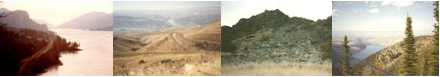
The Columbia originates in two lakes that lie between the Continental Divide and Selkirk mountain ranges in British Columbia. The river’s course is convoluted. It flows north for its first 200 or more miles, then it turns south and runs to the international border. Within the United States, the river courses southwest and skirts one of the Columbia Plateau’s massive lava flows, then it turns to the southeast, cutting a dramatic gorge in the volcanic shield to its junction with the westward flowing Snake River. From its confluence with the Snake, the Columbia runs nearly due west to the Pacific Ocean. Fifteen percent of the basin — 39,000 square miles — lies in Canada and the largest of the river’s major tributaries is the Snake River, itself more than 1,100 miles long. The Columbia River Basin includes a diverse ecology that ranges from temperate rain forests to semi-arid plateaus, with precipitation levels from 110 inches to 6 inches per year.
Most important, perhaps, the Columbia is a snow-charged river that seasonally fluctuates in volume. Its annual average discharge is 160 million acre-feet of water, with the highest volumes between April and September, the lowest from December to February. From its source at 2,650 feet above sea level, the river drops an average of more than 2 feet per mile, but in some sections it falls nearly 5 feet per mile.
The Columbia has ten major tributaries: the Kootenay, Okanagan, Wenatchee, Spokane, Yakima, Snake, Deschutes, Willamette, Cowlitz, and Lewis rivers. Its most important tributary, the Snake, flows across a semi-arid plain and runs through the deepest gorge in North America, Hell’s Canyon — 7,900 feet deep. The Deschutes and Willamette rivers drain basins south of the Columbia, while the Yakima, Lewis, and Cowlitz rivers drain areas on the north side of the river.
An especially dramatically scenic portion of the river cuts through the Cascade Mountain Range, creating the 100-mile-long and 3,000-foot-deep Columbia River Gorge. Before massive dam building the 20th century, the river plunged over basalt cliffs and rapids in the Gorge, but today the engineered Columbia provides a nearly sea-level pathway through the mountain range to eastern regions of Oregon and Washington. The reach of tide extends to the western end of the Gorge, a little more than 100 miles from the ocean. This lower river section is flat, falling less than one half-foot per mile. It includes, Sauvie Island, one of the largest river islands in North America.
Uses of the Columbia
The Columbia River Basin is the most hydroelectrically developed river system in the world. More than 400 dams — 11 run-of-the-river dams on the mainstem — and hundreds of major and modest structures on tributaries block river flows and tap a large portion of the Columbia’s generating capacity: more than 21 million kilowatts. Rock Island Dam on the middle river was the first major hydropower producer on the Columbia. Completed in 1932, Rock Island Dam is small compared to the behemoths — Bonneville and Grand Coulee — that the federal government completed respectively in 1938 and 1941. The last dams built on the Columbia came on line during the 1960s and 1970s. In 1973, Canada completed the last of the mainstem dams, Mica Dam on the upper river. The dams created large reservoirs that provide flood control and water for vast irrigation systems on the Columbia Plateau, and with the completion of four dams on the lower Snake River during the 1970s the engineers strung together a series of slackwater lakes that allowed barges to navigate more than 465 miles from the Pacific to the inland port of Lewiston, Idaho. The hydroelectric projects connect the entire region through a network of interties and relay stations into a powergrid system. A treaty with Canada in 1964 and creation of the NW-SW Intertie with California made the network inter-regional and international.
Dams on the Columbia have contributed significantly to steep declines in historically strong anadromous fish runs. Between the 1860s and 1960s, commercial fisheries annually harvested millions of pounds of fish, especially five species of salmonids. The largest catch came from the estuary and lower river, where fishers used seines and gillnets. On the middle river, native fishers have used dipnets, hooks, and setnets. Since the 1950s, the combined consequences of dams, increased ocean fishing, deterioration of stream and river habitats, and changing river conditions have made the Columbia less and less habitable for anadromous fish. Ever since the early 1970s, the fish catch has dramatically declined, with hatchery-raised species making up more than 80 percent of commercially caught salmon in the river. Fish hatcheries began operation in the Basin in 1877 and became a major mitigation of dam-caused salmon declines during the late 20th century. In 1992, the government listed the native Snake River Sockeye salmon as endangered under the Endangered Species Act, and in 1998 Willamette steelhead joined the list of endangered fish.
Because of the 40-foot-deep channel in the lower river and slackwater lakes on the middle river, ocean freighters can navigate up the Columbia and Willamette rivers to Portland and barges can transport goods to the interior. Towboats push the barges up through navigation locks on Bonneville, The Dalles, John Day, McNary, and four Snake River dams, carrying diesel fuel and other commodities upriver, grain, wood chips, agricultural products, and lumber downriver.
As early as the 1870s, agriculture benefited from Columbia River water. By the 1920s, major irrigation projects along the Columbia and tributaries, such as the Yakima, Wenatchee and Umatilla rivers operated with the benefit of federal programs. During the 1930s and 1940s, however, the construction of the big dams, especially Grand Coulee Dam on the upper river and McNary Dam on the middle river, greatly increased irrigated agriculture on the Columbia Plateau. In 1948, the Columbia Basin Project began transporting Columbia River water by canal to more than 600 thousand acres on farms in central Washington. This project requires massive pumping stations, a labyrinth of canals, and enormous center-pivot sprinkler systems. Major irrigated crops include alfalfa, potatoes, mint, beets, beans, orchard fruit, and wine grapes.
Recreation on the Columbia began early in the settlement era, with steamboat excursions up the Columbia from Portland, especially to the western end of the Columbia River Gorge. Sport fishing for salmon and steelhead developed as early as the 1920s and expanded with the increased use of power boats. Sailing, day cruising, swimming, water skiing, canoeing, and other water sports have become commonplace on the river since World War II. During the 1980s, sailboarders discovered the high and steady winds in the Gorge along the middle river. Hood River, Stevenson, and The Dalles became internationally known destinations for windsurfing. Protectionists, who included many hikers and outdoor enthusiasts, organized a campaign to preserve the Columbia River Gorge’s scenic beauty by successfully encouraging Congress to pass the Columbia River Gorge National Scenic Area Act in 1986. The legislation mandates environmental protection through agreements between federal, state, municipal, and county governments in the Columbia River Gorge.
History
The earliest archaeological evidence of human habitation in the Columbia River Basin dates to 10,000 B.P. [Before Present Time] The earliest groups lived by fishing, hunting large mammals, and gathering plant foods. Cultures in the proto-historic and historic periods varied greatly along the river. On the lower Columbia groups lived in large multi-family long houses, while on the middle and upper river sections, people moved seasonally and lived in smaller groups. Native fishers took salmon at Willamette Falls on the Willamette River and at Kettle Falls on the upper Columbia. Celilo Falls on the middle river was the most important native fishery. Thousands gathered there during the spring and summer fish runs to harvest chinook salmon and trade. In the early 19th century, Pacific Fur Company trader Alexander Ross called Celilo “the great emporium or mart of the Columbia.”
The Columbia River first appeared on European maps in the early 17th century as “River of the West,” when a Spanish maritime explorer Martin de Auguilar located a major river near the 42nd parallel. Cartographers often labeled the “River of the West” as an estuary to the mythical Straits of Anian, or the Northwest Passage and located it anywhere from the 42nd to the 50th parallel. In 1765, British Major Robert Rogers called the river “Ouragon” — later spelled “Oregon” by Jonathan Carver in 1778 — as a derivative name referring to the “ouisconsink” river in present-day Wisconsin. The first confirmation of its location came in 1775 when Bruno de Hezeta described a river estuary at the Columbia’s correct latitude. In May 1792, American trader Captain Robert Gray sailed across the bar in the first documented Euroamerican visit to the river. British explorer George Vancouver sent Lt. William Broughton up the river more than 100 miles in October 1792, and Broughton produced the first detailed map of the lower river. Meriwether Lewis and William Clark explored the river in 1805-1806 for the United States. Northwest Company fur trader David Thompson made the first map of the full river in 1811-1812. After the War of 1812, England and the United States jointly occupied the Columbia River Basin territory.
Britain’s Hudson’s Bay Company [HBC] established a fur-trading hegemony in the region and built a headquarters post at Fort Vancouver in 1825. HBC trappers and traders spread throughout the Columbia River Basin and beyond, bringing furs back to Fort Vancouver for shipment to England. Americans returned to the region as settlers during the 1840s, when overland migrants came to the Columbia and Willamette river valleys on the Oregon Trail. In 1846, the Oregon Country south of the 49th Parallel became United States territory by treaty with Great Britain. Oregon achieved statehood in 1859, Washington and Montana in 1889, and Idaho in 1890.
During the late nineteenth century, capitalists developed natural resource and transportation industries on the Columbia. From 1860 to 1883, Portland’s hegemonic Oregon Steam Navigation Company dominated steamboat transportation on the lower and middle river. R. D. Hume established the first salmon cannery on the Columbia in 1866, and by 1883 forty canneries operated on the river, packing 634,000 48-pound cases for export. During the period 1880-1900, orchardists established operations at Hood River and Wenatchee on the Columbia and along the Yakima and Okanogan rivers. Engineering projects on the river began with navigation canals at Cascade Locks in 1896 and at The Dalles-Celilo in 1915.
Twentieth-century alterations on the Columbia River dwarfed the early dredging and canal building. In 1932, private power companies completed Rock Island Dam on the middle river. In 1933, the federal government began work on Bonneville Dam on the lower river and Grand Coulee Dam on the upper river. By 1975, eleven dams stood on the mainstem, with many additional dams on major tributaries. The hydroelectric resources contributed directly to waging World War II. Electricity from the Columbia River powered aluminum plants, shipyards, and the development of the plutonium atomic bomb at Hanford Engineering Works near Richland, Washington. The hydroelectricity generated on the Columbia has stimulated significant industrial growth in the Pacific Northwest since World War II.